Ram Creek Hot Springs
It is a lovely spot and the temperature of the water just right for laying around as long as you want.

Thumbs Up or Down
0 liked this post
0 didn't like this post
GPS: 50.035753, -115.597286
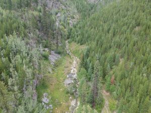
These isolated springs are situated peacefully on a hill at the base of a mountain. They provide stunning views of the verdant meadows below. Few places in the world are more magnificent than this.
The springs are a series of undeveloped rock pools located just off the forestry path.
Since there is little infrastructure here other than a slight trail and pools of water that have been modestly dug out and formed with rocks by hand, they are considered natural hot springs.
They have the feel of a warm spring. The water temperature was comparable to that of a bathtub, hot enough to soak in all day if desired. When visiting RamCreek, you will enjoy two springs. The upper springs have an average temperature of about 92 degrees, while the lower one has an average temperature of about 88 degrees.
Years before, the water was much warmer; a fault change and a landslide demolished and filled up the vast pools.
The water depth is currently a little shallower than waste deep. The water is just below my neck as I sit on your bottom. The ideal depth for lounging!
There are 2 routes to the springs

Route 1) From BC-93N/BC-95N, Turn Right on to Whiteswan Lake Forest Service Rd
Right onto Lussier River Forest Service Rd S
Right on White Ram Forest Service Rd (Ram Creek Road)
Ram Creek Hot Springs is an 11Km lightly trafficked out-and-back trail from here.
The length of the hike depends on how far you’re willing to drive your vehicle on the final stretch of ‘road.’ The last 6 miles (10 kilometers) is more of a quad or ATV trail.
MAP for Lussier route

Route 2:
From BC-93 N/BC-95N
Turn onto PremierLake Rd
Turn right onto Ram Creek Forest Service Rd
follow this till approx 50.037585, -115.610014
From here its a 3.1-kilometer lightly trafficked out-and-back trail
MAP for: Premier Lake Rd Route
Ram Creek Forest Service Road, which formerly ran across Ram Creek Ecological Reserve, has been decommissioned indefinitely.
Motorists should be aware that the Ram Creek Forest Service Road portion that formerly ran across the Ram Creek Ecological Reserve has been permanently deactivated and reclaimed for public protection. Due to significant debris torrent hazards to the geothermal site. All resource roads adjacent to Ram Creek Ecological Reserve remain open.
Featured photo @jachan25 instagram
Also, check out Lussier Hot Springs while you’re up here. If you hit the ditch, snowbank, running out of gas on this journey, call Wrench Bender Towing. They have great rates and will come find you in the middle of the night.
Call Dennis @ (250) 349-5655


Views:
28,515 views


[…] have a similar vibe to Ram Creek Hot Springs but much smaller (There are two pools that can both fit 2 people at most) and take a lot more […]