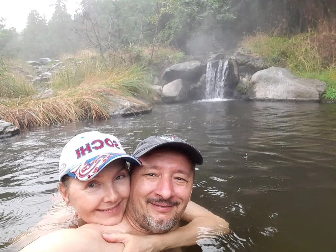
Meager Creek Hot Springs
Thumbs Up or Down
0 liked this post
0 didn't like this post
Meager Creek Hot Springs is a set of prime Springs that were once the most visited non-commercial hot springs in British Columbia. That changed in an Second ,in 2010, when a vast Landslide swept down the Capricorn Creek, roads and bridges and removing all easy access.
The Lillooet River Bridge and meager Creek Road will not be rebuilt. Meaning that for the moment, the Meager Creek Hot Springs are seldom visited; the situation may change in the next few years with the resumption of logging in the upper meager Creek area and the construction of a new road along the southeast side of the creek.
Meager Creek is arguably the most dangerous and unstable Valley in BC. In addition to the giant slide, there have been at least eight other large slides and many smaller ones in the last hundred years. 4 people who were buried in 1975 flow, and their bodies were never found.
To get there, we have two sets of instructions given to us.
Go NW on Pemberton Meadows Road from Pemberton, then zero your odometer. For a few kilometres, the path is stunning, straight, and smooth until the pavement stops and the gravel road starts.
A 4×4 is only needed for the final four kilometres to the trailhead. The logging road becomes really poor at 60 kilometres, and you come to a Y junction; turn left here (the right fork ends 100 metres farther at a logging company’s locked gate). In about 4 kilometres, follow this steep and zig-zagging (4×4 only) logging road to the designated trailhead (see the map below). Hike for 6 kilometres on the Harrison Hut trail before you reach an old logging road junction on your right. Follow the logging road down to the hot springs for 3.5 kilometres.

1. Zero your odometer at Village Gate Boulevard in Whistler Village and Drive North on Highway 99 toward Pemberton
2. at 32.1 km, turn left onto Portage Road. It takes you into downtown Pemberton
3. at 32.9 km, turn left at the round boat onto Birch Drive
4. At 33.1 km, turn right at the stop sign onto Prospect Street, which becomes Pemberton Valley Road at the stop sign at 34.9 km.
5. At 89 kilometers, turn left up the Steep and Winding Road up to the trailhead parking
6) at 93km, you’ve arrived at the trailhead parking for Harrison Hut Trail and the major Hot Springs Trail.

Summer alert: When temperatures exceed 30 °C, the gate at 2km to restrict public access may be locked due to increased landslide risk, as per the Volcanic Landslide Risk Management report. Drivers returning to Pemberton must be prepared to overnight at 2km.
A gate at 24km to restrict public access; the gate will remain locked throughout the year. See the Volcanic Landslide Risk Management report for further details. Turn around and parking is available at 24km.
Meager Creek Recreation Site is closed indefinitely due to the 2010 landslide; no vehicle access to the hot springs via Lillooet South FSR. See the Meager Creek slide area map
April 1 – June 15 and September 16 – November 30 annually: The gate at 2km will be locked to enforce motor vehicle prohibitions through the Wildlife Act.
The Julian Harrison Hut is a massive Gothic A-frame situated 50 kilometres northwest of Pemberton, British Columbia, at an elevation of 1,725 metres (5,659 ft). The Hut is located in a subalpine meadow in the northernmost section of the Pemberton Icefield (south of Meager Creek valley), near the headwaters of Barr (also known as Madhorse) Creek. The typical Meager Creek Valley access is a 12.3km climb that begins at an elevation of 900m and traverses for 6km before starting the remaining 825m of elevation gain. Because of the trail’s general undulating appearance, the average elevation gain is roughly 1200m. The AMS Varsity Outdoor Club currently maintains the Hut.

No reservations are taken, but please see the VOC Hut Registration page to help coordinate use.
See the Bulletins on the Hut Registration Page for the latest up-to-date updates on the Hut.
Both non-motorized, non-commercial users are welcome at VOC huts. To cover hut upkeep, a fee of $10 per person per night is charged. The fee can be submitted to the VOC via our Showpass Donation Page or left in the blue dropbox at the hut. If neither of these works, you can send it to the VOC by mail. During the fall and winter holidays (New Year’s, Reading Week, and Easter), VOC trips take precedence, so please contact the VOC before booking a trip during this period. Before accessing either of the huts, commercial groups could notify the VOC. There is a website for lost and found objects in and near the VOC huts.
Featured photo (+others)and video by @canlifeuz


Additional info!
To get there: we have two sets of instructions given to us.
Go NW on Pemberton Meadows Road from Pemberton, then zero your odometer. For a few kilometres, the path is stunning, straight, and smooth until the pavement stops and the gravel road starts.
A 4×4 is only needed for the final four kilometres to the trailhead. The logging road becomes really poor at 60 kilometres, and you come to a Y junction; turn left here (the right fork ends 100 metres farther at a logging company’s locked gate). In about 4 kilometres, follow this steep and zig-zagging (4×4 only) logging road to the designated trailhead (see the map below). Hike for 6 kilometres on the Harrison Hut trail before you reach an old logging road junction on your right. Follow the logging road down to the hot springs for 3.5 kilometres.
1. Zero your odometer at Village Gate Boulevard in Whistler Village and Drive North on Highway 99 toward Pemberton
2. at 32.1 km, turn left onto Portage Road. It takes you into downtown Pemberton
3. At 32.9 km, turn left at the round boat onto Birch Drive
4. At 33.1 km, turn right at the stop sign onto Prospect Street, which becomes Pemberton Valley Road at the stop sign at 34.9 km.
5. At 89 kilometers, turn left up the Steep and Winding Road up to the trailhead parking
6) At 93km, you’ve arrived at the trailhead parking for Harrison Hut Trail and the major Hot Springs Trail.
Summer alert: When temperatures exceed 30 °C, the gate at 2km to restrict public access may be locked due to increased landslide risk, as per the Volcanic Landslide Risk Management report. Drivers returning to Pemberton must be prepared to overnight at 2km.
A gate at 24km to restrict public access; the gate will remain locked throughout the year. See the Volcanic Landslide Risk Management report for further details. Turn around, and parking is available at 24km.
Meager Creek Recreation Site is closed indefinitely due tothe 2010 landslide; no vehicle access to the hot springs via Lillooet South FSR. See the Meager Creek slide area map.
April 1 – June 15 and September 16 – November 30 annually: The gate at 2km will be locked to enforce motor vehicle prohibitions through the Wildlife Act.
The Julian Harrison Hut is a massive Gothic A-frame situated 50 kilometres northwest of Pemberton, British Columbia, at an elevation of 1,725 metres (5,659 ft). The Hut is located in a subalpine meadow in the northernmost section of the Pemberton Icefield (south of Meager Creek valley), near the headwaters of Barr (also known as Madhorse) Creek. The typical Meager Creek Valley access is a 12.3km climb that begins at an elevation of 900m and traverses for 6km before starting the remaining 825m of elevation gain. Because of the trail’s general undulating appearance, the average elevation gain is roughly 1200m. The AMS Varsity Outdoor Club currently maintains the Hut.
No reservations are taken, but please see the VOC Hut Registration page to help coordinate use.
See the Bulletins on the Hut Registration Page for the latest up-to-date updates on the Hut.
Both non-motorized, non-commercial users are welcome at VOC huts. To cover hut upkeep, a fee of $10 per person per night is charged. The fee can be submitted to the VOC via our Showpass Donation Page or left in the blue dropbox at the hut. If neither of these works, you can send it to the VOC by mail. During the fall and winter holidays (New Year’s, Reading Week, and Easter), VOC trips take precedence, so please contact the VOC before booking a trip during this period. Before accessing either of the huts, commercial groups could notify the VOC. There is a website for lost and found objects in and near the VOC huts.
Featured photo (+others)and video by @canlifeuz
Nqw’elqw’elusten (Meager Creek) Hot Springs are within Lil̓wat Nation territory. This is a place of cultural and spiritual significance for Lil̓wat Nation. The hot springs and Stuqalts (the Upper Lillooet River Valley), provide important habitat for many wildlife species, including the South Chilcotin grizzly bear population. The Upper Lillooet is a very important wildlife migration corridor for deer, moose, and mountain goats. Mineral licks at the hot springs provide wildlife with year-round nutrients.
The hot springs are also home to the vivid dancer damselfly, a species of special concern that is threatened by intensive recreational use. Meager Creek Hot Springs is the only known location within BC where the American bulrush (Schoenoplectus americanus) grows. The Mount Meager Volcanic Complex is one of the most geologically active areas in North America.
MEAGER CREEK HOTSPRTNGS
NATURAL HISTORY SOCIETY
REPORT OF RESEARCH 1987 _ 1988
by Paul D. Kroeserand Michael W. Plumbpublished
1989 by P. Kroeqer
INTRODUCTTON
GEOGRAPHIC LOCATION
The Meager Creek Hotsprings Forestry Recreation Site islocated about 50 kilometers northwest of Pemberton, B.C. orl-50 kilometers north of Vancouver on Meager Creek, a maintributary of the Lillooet River, six kilometers above theirconfluence. This is at an altitude of 600-800 metres in the CoastRanqe mountains of British Columbia. Access is by vehiclealonq the Lillooet Forestry Road. This road is open to thepublic only during times when logging operations are ceased. on weekends and before 6 A.M. or after 6 P.M., and isusually closed after heavy snowfall for the duration of thewinter.
The Meager Creek Hot Springs were discovered in 191-0. Meager Creek is named for J.B.Meager who owned timber leaseson the creek (Akrigg,c.P.V. & Helen B. British ColumbiaPlace Names 1986).
Despite the length of time since theirdiscovery Meager Creek hot springs were little known untilrecently, not being listed in major compilations of knownhotsprings locations done as recently as 1973. In the mid-1970’s, the Department of Energy, Mines and Resources (E.M.R. ) initiated research to assess the potential of Geothermal power generation in British Columbia. As a result, in 1914 and subsequent years, both E.M.R. and British Columbia Hydro and Power Authority conducted intense geological research in the area. Including the drilling of several test boreholes, the first of which, emr 301 – 1 or ddh-1, was drilled on the Meager Creek Hot Springs Terrace. During drilling here, it was noted that a layer of hot Springs deposit, travertine, and opaline silica is present for a depth of 10m. This would indicate that there has been a Hot Springs flow in the area for a considerable period of time.
Views:
14,970 views

I met guys in the nineties that had been coming up a path to Meager on MULES in the dirty thirties. This layout is probably the best for any hotsprings anywhere: flow from a large pond through several small pools, into a cooler pond. Great memories since the eighties. Gotta get me a horse to get in now.